I was asked by an agency to work on a project for a multi-national industrial pump company as part of a national billboard and magazine campaign. The target audience were open cut mine sites and as the budget was relatively humble we had to find a way to complete the project within certain constraints.
 This is the original concept brief that I was presented with. In discussions with the agency the options of shooting at a different time of day or angle were discounted for reasons outside my control. I’m part of a team when I work for an agency hence have to work to the direction I am given.
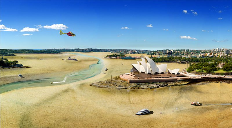
The starting point was the base image of Sydney Harbor shot from the South Pylon lookout on the Harbor Bridge, this is where the reference shot (above) was also taken from.

Part of the brief was a cracked earth harbor floor and without a suitable image to use I decided to build my own model in our car-park, bags of dirt  and clay make plenty of mud and a few days in the sun does the rest and while this gave me the base it was still a little too “outback” so I created a blending layer with sand shot at a nearby beach to give a bit more of a coastal feel.
From that point on it was a matter of trying to visualize what the harbor may look like once you pull the plug. I checked on Google but they had no images that went back to the last Ice age so for me it was simply a matter of looking at the surrounding geography and visualizing where those lines may go.
 Starting with the most obvious feature the Opera House sitting on “ Bennelong Point” I went back to nearby coastal features and looked at some headlands and grabbed a bit of a point on Stradbroke Island.
I slipped that under the Opera House and extended the seawall around the opera house so it looked as though it was reaching down to the point, in addition I added a bit of drainage run off at the same time. I have no idea if the storm water drains are there but I have seen them in other facilities in similar environments.

I used the same method for the entire harbor shore line adding or more so extending the harbor edge so it looked as though it was a very low tide. This uncovered some unanticipated issues that had to be resolved, there was a frigate moored at Garden Island. To resolve  this I found some plans for hull design then recreated that in photoshop and blended with the above waterline image.
In Farm Cove, next to  the Opera House they are constructing some over water decking so this too had to be extended below the waterline
Another aspect I considered was in any river valley there is still some indication of the stream and being an ex Sydney boy I knew that Tank Stream formed part of Circular Quay, to help create this I found features on a coastal beach that had, at a different scale, the style of receding stream that I could blend in to the existing harbor floor.

 Sydney Harbor is a busy place at the best of times and we decided with the agency that it should have some elements of distressed boating features without going over board
(pardon the pun), again visualizing what a boat might look like when it runs out of water. I shot some boats from appropriate angles (while I was shooting the base image) so they would look like they had settled at irregular angles on the harbor floor and included the dregs of the “Tank” stream that you see in dried out inland rivers. The jet boat was actually on the harbor the day I shot the base plate.
For the Photoshop junkies the layers count, including all layer groups, went into the triple figures.
The end result….